
WIMPLE
A wildfire risk assessment and mitigation
solution for homeowners and communities
A wildfire risk assessment and mitigation solution for homeowners and communities
Wildfire Integrated Modeling, Prediction, and Learning Environment (WIMPLE)
WIMPLE, a wildfire risk assessment and simulation system, uses hybrid AI to analyze data from multiple sources and provide a better overall understanding of the effects of climate change on wildfire risk. Over 72,000 US communities exist in areas of high wildfire risk. The risk of wildfires has increased significantly in recent years due to both climate change and expanding communities, with some 45 million homes integrated with wildlands nationally.
Charles River Analytics created WIMPLE to address the increasing need for wildfire risk assessment. The idea for the WIMPLE project was sparked by a conversation on a plane between a Charles River employee and a member of California’s Southern Marin Fire Protection District, which has been pioneering new wildfire risk assessment strategies.
“It’s difficult for a homeowner to understand the risk of wildfire to their home. We can present the information they need in an easy-to-use interface and show them the changes they need to make to protect their property.”

Dr. Sanja Cvijic
Senior Scientist and Principal Investigator on WIMPLE
Current wildfire risk assessment and prediction methods vary widely. Each wildfire researcher uses a different methodology and pulls from different data sets. These information silos give only partial glimpses of the risk of wildfire in any given area, particularly when predicting how climate change may affect future risk. Property assessments are often performed several years apart, which is problematic since officials in Southern Marin County report that wildfire behavior has changed significantly even in the last two years. As a result, homeowners and fire departments struggle to adequately triage and manage the true risk, hindering wildfire prevention and mitigation efforts and increasing economic uncertainty.
WIMPLE can help resolve this problem by analyzing data from multiple sources including NASA Earth Observatory, NASA Visible Earth, NASA GISS global climate model simulations, NOAA/USDA data on fire perimeter history, fire simulators from the US Forestry Service, and more.
A next-generation hybrid AI framework from Charles River called Scruff™ integrates this data using multiple AI models and determines critical wildfire risk factors. Scruff uses flexible spatiotemporal modeling to integrate different kinds of model components, including physical, neural, and statistical models. This gives WIMPLE the flexibility to use data at different scales, from a large region to a single property.

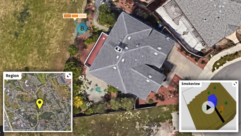
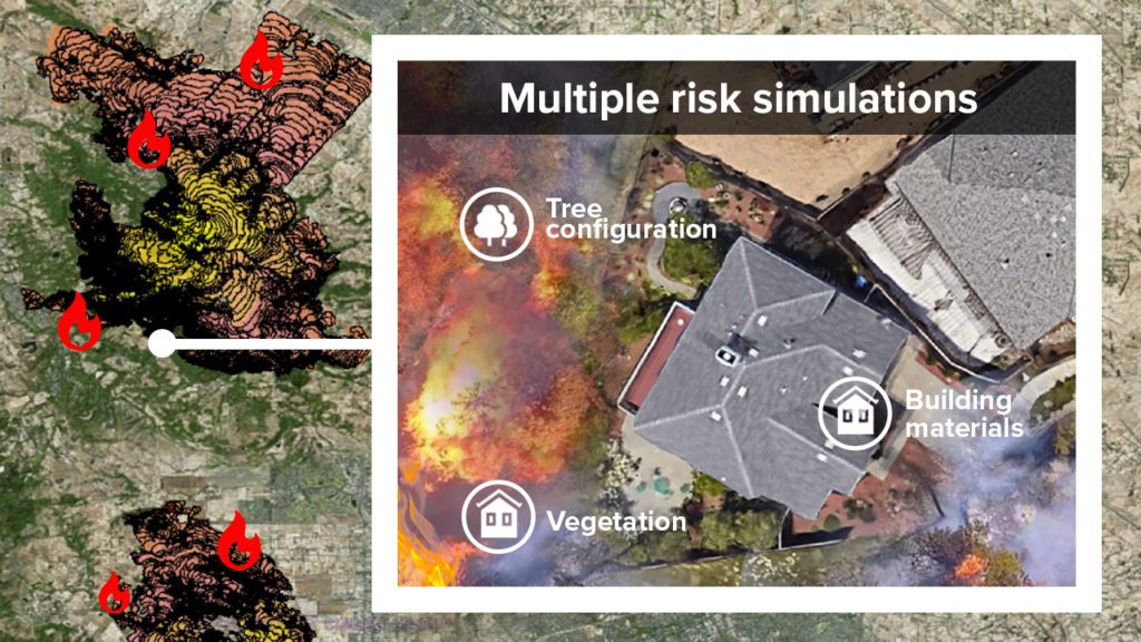
WIMPLE can present homeowners with a simulation of their wildfire risk, including diagrams that show risk zones on their property and the potential threat to their homes. The interface provides suggestions for mitigating that risk, such as clearing gutters, removing undergrowth, and thinning out densely crowded smaller trees to reduce fire intensity and slow the spread of a fire moving toward the home. WIMPLE shows homeowners how to create a defensible space to increase the odds of a home’s survival and minimize damage during a wildfire, including an estimate of reduced costs related to wildfire damage. WIMPLE can also provide wildfire risk simulation on a regional level, indicating the potential propagation and spread of a wildfire within a particular region. With an estimated four million properties at high or extreme risk in the US—more than two million in California alone—WIMPLE has the potential to make a significant impact on wildfire and property management.
Charles River is eager to bring WIMPLE to market. While homeowners are the initial target users for WIMPLE, the system could also benefit a number of other markets such as insurance companies, developers, property managers, utilities, fire departments, conservation groups, and other government entities. Charles River has completed the first phase of a Small Business Innovation Research (SBIR) contract with NASA’s Jet Propulsion Laboratory. Testing of WIMPLE will begin in Phase II of the contract with the coming wildfire season.
Contact us to learn more about WIMPLE, Scruff, and our other humanitarian and environmental and artificial intelligence capabilities.