Charles River Analytics Inc., a developer of advanced technologies for intelligent systems, received a contract award to develop RELIANCE (Registration of EO and LIDAR using an Interoperability Architecture for Net-Centric Environments). RELIANCE accurately maps video streams from multiple airborne sensors onto a common view of the battlefield in real time, to overcome the so-called “soda straw syndrome” caused by the limited field of view of most current full motion video (FMV) sensors. The software renders live video from FMV sensors onto a virtual globe with 3D terrain, and annotates the video with geographic information system (GIS) layers. The DoD-sponsored contract is valued over $1 million, plus options for enhancements.
Daniel Gutchess, Senior Software Engineer at Charles River, explained, “Our system is similar to Google Earth™, but can display live video painted onto 3D terrain. Unlike static satellite imagery, which may be a year old or more, RELIANCE provides an up-to-the-second view of the Earth. It allows the video to be marked up with geospatial information, such as labeled locations of interest from a GIS database. It also lets the user zoom out beyond the soda straw and visualize information in the wider context of locations and events outside the video camera’s current field of view.”
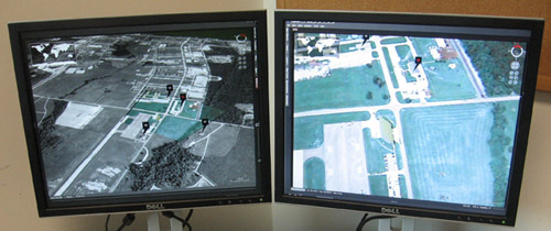
RELIANCE’s dual-screen interface. Left: live video transformed onto a 3D map display. Right: Raw video with geospatial annotations.
RELIANCE provides a number of key benefits to the warfighter. The system is based on an open architecture, allowing its 3D map display to be augmented with information from other sensors and systems. By precisely mapping video to ground coordinates, RELIANCE can substantially improve the ability to collect geospatially accurate intelligence. Mr. Gutchess noted, “The increased accuracy will ensure, for example, that the correct building is identified in a densely-populated urban area. As a result, we believe the technology has the potential to significantly reduce collateral damage and friendly fire incidents.”
RELIANCE’s georegistration technology can also be applied to a number of non-military applications where accurate geolocation is required and imaging is used to track or observe objects on the ground, such as emergency operations, law enforcement, commercial mapping and surveying, agriculture, and environmental studies.
Magnús Snorrason, Principal Scientist, Sensor Processing and Networking, said, “We are particularly excited about tackling this geospatial accuracy issue because this is such an important problem for so many users. The proliferation of airborne video sensors is of little use if there’s no way to tell exactly where the video was taken. The goal of RELIANCE is to solve spatial inaccuracy issues in a way that is completely transparent to the user.”
This material is based upon work supported by The United States Special Operations Command under Contract No. H92222-11-C-0010. Any opinions, findings and conclusions or recommendations expressed in this material are those of the author(s) and do not necessarily reflect the views of The United Special Operations Command.