
The Situation
The dependability, persistence, and versatility of unmanned aerial systems (UAS) have made them indispensable assets to provide intelligence, surveillance, and reconnaissance (ISR) over the battlefield. As larger constellations of heterogeneous, multi-purpose UAS are tasked to perform more diverse missions in unpredictable, dynamic environments with more sophisticated sensors, they are transitioning from remote control into the realm of more autonomous operations. Intelligent systems have the potential to provide this autonomy and augment human capabilities in collection planning for these missions, but it is essential to understand how they might optimize against multiple competing objectives. Generating optimal collection plans for airborne ISR assets remains a challenging problem given the complexity of the search space, the number and variety of aircraft available to perform these missions, and the complexity of the underlying geospatial data available. These challenges, coupled with the increasing number of sensor types and aircraft platforms, present a challenge for human ISR collection planners and human UAS operators to optimize their use. Mission planners need to understand the capabilities and limitations of their aircraft in various mission scenarios before they can confidently and effectively use mission planning decision aids during semi-autonomous operations.
The Charles River Analytics Solution
Scientists and software engineers at Charles River Analytics developed a tactical decision aid to generate Spatially Produced Airspace Routes from Tactically Evolved Networks (SPARTEN). SPARTEN generates coordinated mission plan solutions for constellations of heterogeneous UAVs with multiple flight goals and objectives. SPARTEN uses an evolutionary algorithm–based multi-objective optimization algorithm to generate coordinated flight routes. These routes maximize coverage, avoid airspace conflicts between UAVs, minimize the latency of sensor data, maximize sensor performance, avoid audio detection from the ground, and avoid adverse weather effects. Our computational formulae for each optimization objective represents quantifications of complex time-varying geospatial data and summarizes the efficacy of each ISR collection plan for multiple heterogeneous UAS assets. SPARTEN allows operators to specify the most important objectives based on their specific tactical needs, which enables the generation of useful collection routes in near real time based on rigorous mathematical foundations while also reflecting the operational needs of the warfighter for specific missions.
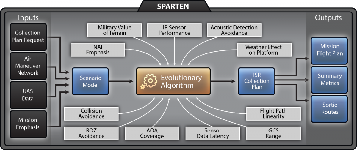
SPARTEN technical architecture
The Benefit
SPARTEN is a decision aid that helps mission planners and unmanned system operators understand the effectiveness of their mission plans for constellations of UAS by making use of available geospatial and temporal data. Novel visualization techniques using GIS help users “look under the hood” of the planning algorithms to understand the viability and effectiveness of mission plans to identify coverage gaps and other inefficiencies. The SPARTEN decision aid makes UAS route planning more efficient and effective as UAS become more autonomous.
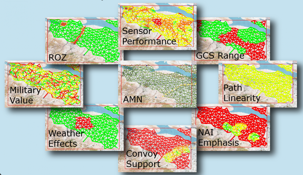
Optimization objectives overlaid on an air maneuver network of possible flight corridors showing the relative fitness of route options
This material is based upon work supported by the United States Army under Contract No. W9132V-13-C-0001. Any opinions, findings and conclusions or recommendations expressed in this material are those of the author(s) and do not necessarily reflect the views of the United States Army.