

“With COMPASS, operational planners and decision-makers can access more reliable and longer-term weather and climate predictions.” – Alison O’Connor, Technical Lead
Combining Long-Range Forecasts
COMPASS successfully combines long-range forecasts developed by international modeling centers to generate a unified forecast for a specific time period, region, and set of environmental conditions that outperforms other available forecasts.
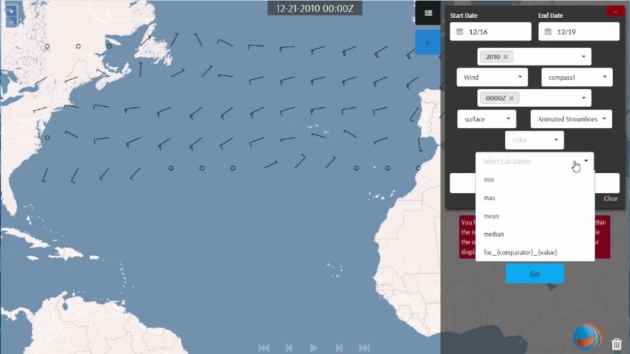
A COMPASS-generated forecast of wind predictions over the Atlantic Ocean displayed in the Advanced Climate Analysis and Forecast System-Decision Support System (ACAF-DSS) developed by Clear Science, Inc.
“We successfully demonstrated COMPASS forecasts integrated within the Navy’s enterprise climate analysis tool, the Advanced Climate Analysis and Forecast System-Decision Support System,” said Alison O’Connor. “This system can now display COMPASS predictions in several ways.”
COMPASS first ingests multiple forecasts available from different modeling centers for a given mission. It then evaluates each individual forecast by comparing its historical predictions to what actually occurred in the same region and time period in previous years. From this, it learns the most skillful combination of the forecasts for the given year using machine learning techniques.
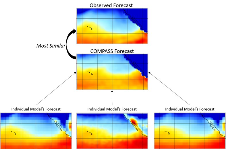
As illustrated below, the COMPASS forecast for the region spanning Honolulu, Hawaii, and San Diego, California, most resembles the observed forecast of what actually happened, compared to less sophisticated, individual forecasts.
COMPASS produces a single, unified long-range forecast of the probability of how conditions will deviate from long-term average climatology or mission-specific thresholds.
A Unified, Superior Forecast
COMPASS intelligently combines multiple forecasts to generate a unified, superior forecast that:
- Improves mission readiness and effectiveness
- Ensures safety
- Reduces cost, labor, and resource requirements
With COMPASS, operational planners and decision-makers can plan missions using more reliable and longer-term weather and climate predictions, adding long-range forecasting capabilities to current forecasting systems and mission-planning tools. Non-expert personnel can generate and interpret forecasts without needing to know which forecast is best under specific circumstances, or the best method to combine forecasts.
Thanks to our mission-specific user interface (UI), planners avoid the time-consuming task of comparing forecasts against mission requirements. Planners can visualize the skill and uncertainty of forecasts to better understand how the forecast impacts a mission.
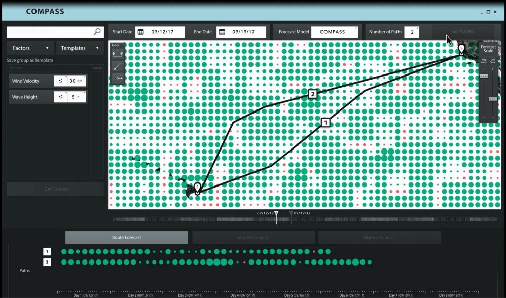
With the COMPASS interface, planners can view alternate routes and time periods to identify the best conditions for the mission. The interface automatically compares forecasts to mission requirements—green circles indicate the forecast for the sub-region satisfies mission requirements (such as wind velocity <= 30 kts and wave height <5’) and circle size indicates confidence in the prediction.
This material is based upon work supported by the Office of Naval Research (ONR) under Contract No. N68335-16-C-0087. Any opinions, findings and conclusions or recommendations expressed in this material are those of the author(s) and do not necessarily reflect the views of the Office of Naval Research (ONR).
DISTRIBUTION STATEMENT A. Approved for public release; distribution is unlimited.